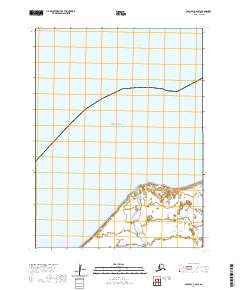
2020 Map of Cold Bay A-6 SW
USGS Topo · Published 2020About this map
Unimak Island serves as the focal point for this coastal survey along the eastern edge of the Aleutians. The landscape is defined by the interaction between the northern coastline and the Bering Sea, where the shore meets the water at Rocky River Point. This area of the island is characterized by low-lying wetlands and minor drainage systems like Coal Oil Cr that snake through the coastal plain. Unlike more developed regions, the map highlights a largely uninhabited shoreline where the primary features are natural landforms and the established boundaries of the Public Land Survey System, including t59s r97w and t60s r96w. The lack of infrastructure emphasizes the isolation of this part of the Alaska Peninsula region, focusing entirely on the topography of the tundra and its tidal reaches.
Find a feature on this map
8 named features on this map. Tap any name to fly to it.
Don’t see what you’re looking for? This feature index may not catch every label — zoom into the map to look around manually.
Map Details
Editions of this 2020 Cold Bay A-6 SW Map
This is the sole edition of this map. No revisions or reprints were ever made.
Other maps of this area

1943 · Fort Randall
USGS Topo · 1:250,000

1949 · False Pass
USGS Topo · 1:250,000

1949 · Fort Randall
USGS Topo · 1:250,000

1950 · False Pass
USGS Topo · 1:250,000

1950 · Fort Randall
USGS Topo · 1:250,000

1951 · Unimak
USGS Topo · 1:250,000

1958 · Unimak
USGS Topo · 1:250,000
1989 · Unimak D-1
USGS Topo · 1:63,360
1989 · Cold Bay A-6
USGS Topo · 1:63,360
1989 · False Pass D-6
USGS Topo · 1:63,360