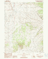
1990 Map of Cold Creek Ranch NW
USGS Topo · Published 1990About this map
Huntington Valley and Newark Valley meet in this landscape of historical transit corridors and mining prospects. The map documents the enduring paths of the Pony Express Trail and the Route of Elko-Hamilton Stage Line, highlighting the area's importance as a thoroughfare for nineteenth-century mail and passenger travel. Evidence of this era is found at the Jacobs Well Pony Express Station (Ruins) located near Huntington Creek. The terrain is marked by numerous prospects and a Landing Strip, suggesting a transition from traditional livestock or transit operations to later industrial exploration. The drainage patterns of Water Canyon and Bourne Canyon define the eastern slopes, while the valley floors contain essential water resources like Huntington Creek.
Find a feature on this map
14 named features on this map. Tap any name to fly to it.
Don’t see what you’re looking for? This feature index may not catch every label — zoom into the map to look around manually.
Map Details
Editions of this 1990 Cold Creek Ranch NW Map
This is the sole edition of this map. No revisions or reprints were ever made.
Other maps of this area

1934 · Jiggs
USGS Topo · 1:125,000

1937 · Jiggs
USGS Topo · 1:125,000

1955 · Elko
USGS Topo · 1:250,000

1956 · Ely
USGS Topo · 1:250,000

1957 · Diamond Springs
USGS Topo · 1:62,500

1957 · Cold Creek Ranch
USGS Topo · 1:62,500

1958 · Elko
USGS Topo · 1:250,000

1959 · Ely
USGS Topo · 1:250,000

1959 · Railroad Pass
USGS Topo · 1:62,500

1959 · Sherman Mtn
USGS Topo · 1:62,500