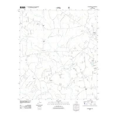
2010 Map of Coldspring
USGS Topo · Published 2010About this map
Coldspring serves as the focal point of this San Jacinto County landscape, where the East Fork San Jacinto River and its numerous tributaries like Miller Creek and Ross Branch carve through the terrain. The region's history is deeply rooted in its rural settlements and local industry, as evidenced by the presence of the Coldspring Oil Field and Coline Oil Field. For those researching local families, the map is a primary resource, documenting the exact locations of the Laurel Hill Cemetery, Spring Hill Cemetery, Evergreen Cemetery, Youngblood Cemetery, and Butler Cemetery. The map also illustrates the natural and recreational character of the area, featuring the Double Lake Campground and segments of the Lone Star Trail Primitive Camp Number One. This combination of industrial activity and preserved woodland, anchored by the Liberty Hill Lookout, provides a clear view of the area's development and geography at the turn of the decade.
Find a feature on this map
56 named features on this map. Tap any name to fly to it.
Don’t see what you’re looking for? This feature index may not catch every label — zoom into the map to look around manually.
Map Details
Editions of this 2010 Coldspring Map
This is the sole edition of this map. No revisions or reprints were ever made.
Other maps of this area

1954 · Beaumont
USGS Topo · 1:250,000

1957 · Beaumont
USGS Topo · 1:250,000

1958 · Westcott
USGS Topo · 1:24,000

1958 · Bear Creek
USGS Topo · 1:24,000

1959 · Conroe NE
USGS Topo · 1:24,000

1960 · Blanchard
USGS Topo · 1:24,000

1960 · Maynard
USGS Topo · 1:24,000

1960 · Stephen Creek
USGS Topo · 1:24,000

1960 · Camilla
USGS Topo · 1:24,000

1960 · Coldspring
USGS Topo · 1:24,000