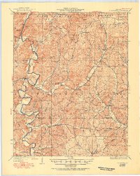
1930 Map of Coldwater
USGS Topo · Published 1951About this map
The Saint Francois National Forest dominates this Ozark landscape, where early 20th-century life centered on the river forks and mountain hollows. Along the St Francis River, travelers navigated numerous crossings such as Wide Ford and Shelton Ford, while the surrounding timberlands were dotted with small, family-centric settlements like French Mills and Lodi. The map reveals a highly localized social infrastructure, with schools such as King Sch and Paullus Sch serving isolated rural communities.
Find a feature on this map
64 named features on this map. Tap any name to fly to it.
Don’t see what you’re looking for? This feature index may not catch every label — zoom into the map to look around manually.
Map Details
Editions of this 1930 Coldwater Map
4 editions found

Other maps of this area

1910 · Higdon
USGS Topo · 1:62,500

1926 · Des Arc
USGS Topo · 1:62,500

1929 · Des Arc
USGS Topo · 1:62,500

1930 · Coldwater
USGS Topo · 1:62,500

1932 · Piedmont
USGS Topo · 1:62,500

1933 · Marquand
USGS Topo · 1:62,500

1934 · Greenville
USGS Topo · 1:62,500

1935 · Zalma
USGS Topo · 1:62,500

1935 · Piedmont
USGS Topo · 1:62,500

1937 · Ironton
USGS Topo · 1:48,000