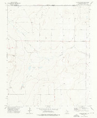
1973 Map of Coldwater West
USGS Topo · Published 1976About this map
Coldwater Creek and the ephemeral Cold Draw carve through the high plains of the Texas Panhandle near the border of Oklahoma and Texas. This 1973 field-checked survey reveals an arid landscape defined by critical water sources, including Government Spring, Potato Spring, and Compound Spring. These perennial points were essential for cattle ranching in the northern reaches of Dallam County and Cimarron County.
Find a feature on this map
12 named features on this map. Tap any name to fly to it.
Don’t see what you’re looking for? This feature index may not catch every label — zoom into the map to look around manually.
Map Details
Editions of this 1973 Coldwater West Map
This is the sole edition of this map. No revisions or reprints were ever made.
Other maps of this area

1954 · Dalhart
USGS Topo · 1:250,000

1958 · Dalhart
USGS Topo · 1:250,000

1962 · Dalhart
USGS Topo · 1:250,000

1969 · Boise City SW
USGS Topo · 1:24,000

1969 · Felt
USGS Topo · 1:24,000

1969 · Boise City SE
USGS Topo · 1:24,000

1973 · Buffalo Springs
USGS Topo · 1:24,000

1973 · Tovrea Ranch
USGS Topo · 1:24,000

1973 · Perico
USGS Topo · 1:24,000

1973 · Coldwater East
USGS Topo · 1:24,000