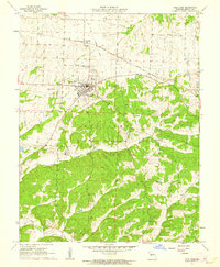
1961 Map of Cole Camp
USGS Topo · Published 1962About this map
Cole Camp stands as the primary hub in this early 1960s study of central Missouri, situated at the intersection of local commerce and transportation. The town's layout is intricately tied to the Chicago Rock Island and Pacific railroad, which defines the northern edge of the settlement near Cole Camp Station. Beyond the grid of the town, the map reveals a high density of rural religious and burial sites, including Trinity Cemetery, Eickhoff Cemetery, and St Johns Church, reflecting a deeply rooted local genealogy.
Find a feature on this map
20 named features on this map. Tap any name to fly to it.
Don’t see what you’re looking for? This feature index may not catch every label — zoom into the map to look around manually.
Map Details
Editions of this 1961 Cole Camp Map
2 editions found
Other maps of this area

1887 · Sedalia
USGS Topo · 1:125,000

1887 · Warsaw
USGS Topo · 1:125,000

1894 · Warsaw
USGS Topo · 1:125,000

1894 · Sedalia
USGS Topo · 1:125,000

1935 · Boylers Mill
USGS Topo · 1:24,000

1936 · Lakeview Heights
USGS Topo · 1:24,000

1936 · Schuyler
USGS Topo · 1:24,000

1947 · Jefferson City
USGS Topo · 1:250,000
1948 · Green Ridge
USGS Topo · 1:62,500

1954 · Jefferson City
USGS Topo · 1:250,000