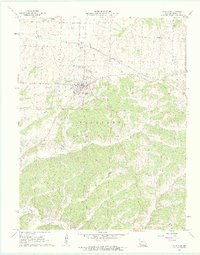
1961 Map of Cole Camp
USGS Topo · Published 1962About this map
Cole Camp serves as the central hub of this Missouri landscape, situated just as the rail lines influenced local development in the early 1960s. The presence of the Chicago Rock Island and Pacific railroad, along with a clearly marked Old Railroad Grade, illustrates the shifting transportation patterns of the era. The area is dense with genealogical markers, particularly around the main settlement where Trinity Cem, Eickhoff Cem, Cole Camp Memorial Cem, and St Pauls Cem are clustered.
Find a feature on this map
25 named features on this map. Tap any name to fly to it.
Don’t see what you’re looking for? This feature index may not catch every label — zoom into the map to look around manually.
Map Details
Editions of this 1961 Cole Camp Map
2 editions found
Other maps of this area

1887 · Sedalia
USGS Topo · 1:125,000

1887 · Warsaw
USGS Topo · 1:125,000

1894 · Warsaw
USGS Topo · 1:125,000

1894 · Sedalia
USGS Topo · 1:125,000

1935 · Boylers Mill
USGS Topo · 1:24,000

1936 · Lakeview Heights
USGS Topo · 1:24,000

1936 · Schuyler
USGS Topo · 1:24,000

1947 · Jefferson City
USGS Topo · 1:250,000
1948 · Green Ridge
USGS Topo · 1:62,500

1954 · Jefferson City
USGS Topo · 1:250,000