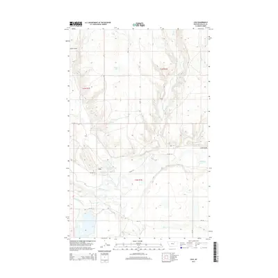
2014 Map of Cole
USGS Topo · Published 2014About this map
Cole sits at the heart of this Phillips County landscape, situated along the winding course of the Milk River. The area's agricultural character is defined by the sophisticated water management of the Nelson South Canal and Nelson S Canal, which draw from the river to support the surrounding plains. The terrain is deeply etched by water, from the namesake Cole Ponds and Carter Lake to numerous named springs like Busche Spring and Zenor Spring. To the north and south, the geography transitions into drainage features such as Hymer Coulee and Little Coulee, while the oddly named Stinky Cr and Dry Stinky Cr contribute to the local hydrography. This 2014 survey documents the persistence of small rural settlements and their reliance on the complex network of canals and natural waterways that have shaped this portion of Northern Montana for generations.
Find a feature on this map
24 named features on this map. Tap any name to fly to it.
Don’t see what you’re looking for? This feature index may not catch every label — zoom into the map to look around manually.
Map Details
Editions of this 2014 Cole Map
This is the sole edition of this map. No revisions or reprints were ever made.
Other maps of this area

1905 · Bowdoin
USGS Topo · 1:62,500

1905 · Saco Special
USGS Topo · 1:62,500

1920 · Cowan
USGS Topo · 1:125,000

1954 · Glasgow
USGS Topo · 1:250,000

1957 · Glasgow
USGS Topo · 1:250,000

1958 · Glasgow
USGS Topo · 1:250,000

1968 · Tattnall
USGS Topo · 1:24,000
1968 · Hewitt Lake
USGS Topo · 1:24,000

1984 · Cole
USGS Topo · 1:24,000
1984 · Robinson Ranch
USGS Topo · 1:24,000