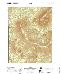
2018 Map of Coleen A-4 SW
USGS Topo · Published 2018About this map
Coleen Mtn and Mt Marr dominate this interior Alaskan landscape within the Yukon-Koyukuk region, where the terrain is defined by dramatic elevation changes. This 2018 survey records a remote wilderness divided by the Public Land Survey System into several townships, including t27n r22e and t26n r23e. The map illustrates the topographic complexity of the northern interior before any significant infrastructure or road networks reached this particular sector. This lack of human-made features, such as those typically documented by the Alaska Dept. of Transportation, highlights the area's status as an undisturbed natural environment. The contour lines, derived from the National Elevation Dataset, trace the high ridges and deep valleys that characterize this portion of the Coleen river basin region.
Find a feature on this map
8 named features on this map. Tap any name to fly to it.
Don’t see what you’re looking for? This feature index may not catch every label — zoom into the map to look around manually.
Map Details
Editions of this 2018 Coleen A-4 SW Map
This is the sole edition of this map. No revisions or reprints were ever made.
Other maps of this area

1951 · Black River
USGS Topo · 1:250,000

1951 · Coleen
USGS Topo · 1:250,000

1956 · Coleen
USGS Topo · 1:250,000

1956 · Coleen A-5
USGS Topo · 1:63,360

1956 · Black River D-4
USGS Topo · 1:63,360

1956 · Black River D-5
USGS Topo · 1:63,360

1956 · Coleen A-4
USGS Topo · 1:63,360

1956 · Black River
USGS Topo · 1:250,000

1964 · Black River
USGS Topo · 1:250,000
2018 · Coleen A-4 NE
USGS Topo · 1:25,000