
1990 Map of Coleen B-5
USGS Topo · Published 1990About this map
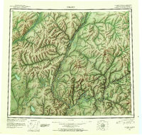
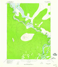
The Arctic National Wildlife Refuge dominates the high-latitude terrain of this late twentieth-century survey, where the landscape is defined by the drainage patterns of the Yukon River watershed. The boundary between the Arctic refuge and the Yukon Flats National Wildlife Refuge cuts across the southern portion of the sheet, marking a transition toward the low-lying wetlands and complex water bodies of the flats. While the area is largely devoid of permanent settlements, a lone Cabin is recorded in the southern interior near a cluster of unnamed lakes. The northern reach is characterized by the headwaters of Boulder Creek, while Grayling Creek flows through the southeastern corner, illustrating the intricate hydrological network that sustains this subarctic environment.
Find a feature on this map
14 named features on this map. Tap any name to fly to it.
Don’t see what you’re looking for? This feature index may not catch every label — zoom into the map to look around manually.
Map Details
Editions of this 1990 Coleen B-5 Map
This is the sole edition of this map. No revisions or reprints were ever made.
Other maps of this area
1951 · Coleen
USGS Topo · 1:250,000
1956 · Coleen
USGS Topo · 1:250,000
1956 · Coleen A-5
USGS Topo · 1:63,360
1956 · Coleen A-6
USGS Topo · 1:63,360
1956 · Coleen A-4
USGS Topo · 1:63,360

1983 · Coleen C-6
USGS Topo · 1:63,360

1990 · Coleen C-4
USGS Topo · 1:63,360

1990 · Coleen B-6
USGS Topo · 1:63,360

1990 · Coleen B-4
USGS Topo · 1:63,360

1990 · Coleen C-5
USGS Topo · 1:63,360