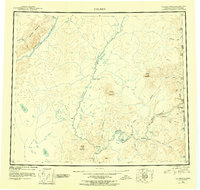
1951 Map of Coleen
USGS Topo · Published 1956About this map
The Porcupine River and its major tributaries, the Coleen River and Sheenjek River, define this subarctic landscape along the international boundary between Alaska and Canada. In the early 1950s, this region remained a wilderness of river-driven geography, where human presence was marked by isolated outposts like Old Rampart and the Owens Cabins along the water's edge. The terrain transitions from the river lowlands at Fishhook Bend to prominent elevations such as Rabbit Mountain and Shoulder Mountain. The eastern edge follows the United States Canada border, documented by numerous monument markers and boundary peaks like Canalaska Mtn. These early surveys reflect a period when seasonal hunting, trapping, and mapping expeditions were the primary activities in the remote drainage basins of the Salmon Trout River and Rapid River.
Find a feature on this map
48 named features on this map. Tap any name to fly to it.
Don’t see what you’re looking for? This feature index may not catch every label — zoom into the map to look around manually.
Map Details
Editions of this 1951 Coleen Map
4 editions found
Other maps of this area

1951 · Fort Yukon
USGS Topo · 1:250,000

1951 · Black River
USGS Topo · 1:250,000

1951 · Coleen
USGS Topo · 1:250,000

1951 · Christian
USGS Topo · 1:250,000

1951 · Arctic
USGS Topo · 1:250,000

1951 · Table Mountain
USGS Topo · 1:250,000

1956 · Table Mountain
USGS Topo · 1:250,000

1956 · Coleen
USGS Topo · 1:250,000

1956 · Arctic
USGS Topo · 1:250,000

1956 · Coleen B-2
USGS Topo · 1:63,360