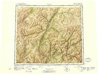
1951 Map of Coleen
USGS Topo · Published 1956About this map
Coleen River and the Porcupine River dominate this 1950s reconnaissance, capturing a remote landscape along the international border between Alaska and the Yukon. At the confluence of the Porcupine and Salmon Trout River, the settlement of Old Rampart stands as a focal point of human activity in an otherwise wilderness-dominated terrain. Small outposts like Owens Cabins and several unnamed cabins along the watercourses suggest a seasonal reliance on the river networks for trapping or travel. The map provides significant topographical detail for aviation and navigation, marking prominent heights such as Rabbit Mountain, Spike Mountain, and Canalaska Mtn. To the west, the Sheenjek River flows past Shoulder Mountain, while numerous unnamed lakes and features like Graphite Lake and Marten Island highlight the complex drainage patterns of the interior before modern development reached this frontier.
Find a feature on this map
43 named features on this map. Tap any name to fly to it.
Don’t see what you’re looking for? This feature index may not catch every label — zoom into the map to look around manually.
Map Details
Editions of this 1951 Coleen Map
4 editions found
Other maps of this area

1951 · Fort Yukon
USGS Topo · 1:250,000

1951 · Black River
USGS Topo · 1:250,000

1951 · Coleen
USGS Topo · 1:250,000

1951 · Christian
USGS Topo · 1:250,000

1951 · Arctic
USGS Topo · 1:250,000

1951 · Table Mountain
USGS Topo · 1:250,000

1956 · Table Mountain
USGS Topo · 1:250,000

1956 · Coleen
USGS Topo · 1:250,000

1956 · Arctic
USGS Topo · 1:250,000

1956 · Coleen B-2
USGS Topo · 1:63,360