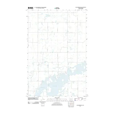
2011 Map of Coleharbor NW
USGS Topo · Published 2011About this map
Audubon Lake dominates the southern landscape of this McLean County region, where the prairie transitions into the complex, irregular shoreline of the reservoir. The map reveals a highly structured grid of section-line roads, such as 22nd St NW and 28th Ave NW, which carve the North Dakota plains into precise agricultural blocks. This geometric order is broken only by the expansive waters of Lake Audubon and the myriad of small prairie potholes and wetlands that dot the northern sections. While the upper reaches remain dedicated to large-scale farming, the southern portion near County Hwy 8 shows localized road developments like Cabin Dr and 30th St SW, indicating the area's use for recreation and shoreline access during the early 21st century.
Find a feature on this map
18 named features on this map. Tap any name to fly to it.
Don’t see what you’re looking for? This feature index may not catch every label — zoom into the map to look around manually.
Map Details
Editions of this 2011 Coleharbor NW Map
This is the sole edition of this map. No revisions or reprints were ever made.
Other maps of this area

1922 · Garrison
USGS Topo · 1:62,500

1929 · Coleharbor
USGS Topo · 1:62,500

1929 · Benedict
USGS Topo · 1:62,500

1954 · McClusky
USGS Topo · 1:250,000

1958 · McClusky
USGS Topo · 1:250,000

1961 · Lake Nettie
USGS Topo · 1:24,000
1972 · Coleharbor
USGS Topo · 1:24,000
1972 · Riverdale North
USGS Topo · 1:24,000

1974 · Benedict SE
USGS Topo · 1:24,000
1974 · Coleharbor NE
USGS Topo · 1:24,000