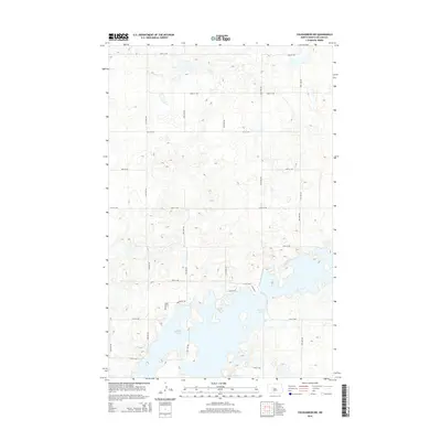
2014 Map of Coleharbor NW
USGS Topo · Published 2014About this map
Audubon Lake dominates the southern landscape of this McLean County quadrangle, where its irregular shoreline and scattered islands define the local geography. The area reflects a modern rural layout, with a strict grid of section-line roads like 23rd St NW and 30th Ave NW providing access to the higher, undulating plains above the water. A cluster of residential development is visible along the lake's northern edge, characterized by the winding paths of Northview Dr and Northview Loop. This pattern of straight agricultural roads intersecting with the organic contours of the reservoir's banks illustrates the intersection of North Dakota’s land-use history and significant 20th-century water management projects. Local access to the water's edge is facilitated by small collector roads such as Cabin Dr W and Cabin Dr E.
Find a feature on this map
22 named features on this map. Tap any name to fly to it.
Don’t see what you’re looking for? This feature index may not catch every label — zoom into the map to look around manually.
Map Details
Editions of this 2014 Coleharbor NW Map
This is the sole edition of this map. No revisions or reprints were ever made.
Other maps of this area

1922 · Garrison
USGS Topo · 1:62,500

1929 · Coleharbor
USGS Topo · 1:62,500

1929 · Benedict
USGS Topo · 1:62,500

1954 · McClusky
USGS Topo · 1:250,000

1958 · McClusky
USGS Topo · 1:250,000

1961 · Lake Nettie
USGS Topo · 1:24,000
1972 · Coleharbor
USGS Topo · 1:24,000
1972 · Riverdale North
USGS Topo · 1:24,000

1974 · Benedict SE
USGS Topo · 1:24,000
1974 · Coleharbor NE
USGS Topo · 1:24,000