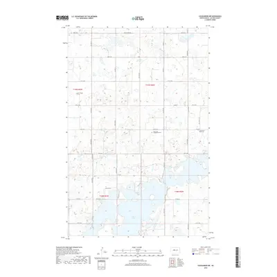
2018 Map of Coleharbor NW
USGS Topo · Published 2018About this map
Audubon Lake dominates the southern landscape of this McLean County region, where the prairie meets the intricate shoreline of the reservoir's northern reaches. The area is defined by its agrarian section lines and a network of county highways and rural routes such as Walleye Way and Cabin Dr, reflecting the area's dual character as both a farming community and a recreational destination. Several small cemeteries, including Endres Cath Cem, Saint Johns Congregational Cem, and the First German Baptist Cem, serve as quiet markers of the early European settlement patterns and religious heritage that took root in this part of North Dakota. The topography is marked by numerous small wetlands and depressions typical of the Missouri Plateau, interspersed with a grid of local roads like Snow Covered Rd.
Find a feature on this map
37 named features on this map. Tap any name to fly to it.
Don’t see what you’re looking for? This feature index may not catch every label — zoom into the map to look around manually.
Map Details
Editions of this 2018 Coleharbor NW Map
This is the sole edition of this map. No revisions or reprints were ever made.
Other maps of this area

1922 · Garrison
USGS Topo · 1:62,500

1929 · Coleharbor
USGS Topo · 1:62,500

1929 · Benedict
USGS Topo · 1:62,500

1954 · McClusky
USGS Topo · 1:250,000

1958 · McClusky
USGS Topo · 1:250,000

1961 · Lake Nettie
USGS Topo · 1:24,000
1972 · Coleharbor
USGS Topo · 1:24,000
1972 · Riverdale North
USGS Topo · 1:24,000

1974 · Benedict SE
USGS Topo · 1:24,000
1974 · Coleharbor NE
USGS Topo · 1:24,000