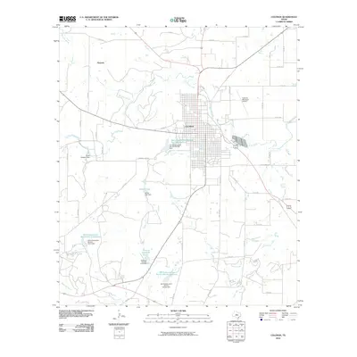
2010 Map of Coleman
USGS Topo · Published 2010About this map
Coleman serves as the central hub of this West Texas landscape, where a grid of residential streets and commercial corridors meets the sprawling agricultural surroundings of Coleman County. The town is flanked by a complex system of water management features, including the Soil Conservation Service Site 38a Reservoir and Hunter Lake, which illustrate the region's reliance on engineered catchment for both municipal use and land conservation. To the northwest, the small settlement of Hamrick sits near the upper reaches of Bachelor Prong. The area is defined by its drainage networks, with Wildcat Creek and Loss Creek carving paths through the terrain. Evidence of local landownership and infrastructure is visible in landmarks like the Taylor Brothers Dam and the Coleman Municipal Airport, reflecting a community integrated with its rural environment and aviation needs.
Find a feature on this map
53 named features on this map. Tap any name to fly to it.
Don’t see what you’re looking for? This feature index may not catch every label — zoom into the map to look around manually.
Map Details
Editions of this 2010 Coleman Map
This is the sole edition of this map. No revisions or reprints were ever made.
Other maps of this area

1887 · Coleman
USGS Topo · 1:125,000

1889 · Coleman
USGS Topo · 1:125,000

1892 · Ballinger
USGS Topo · 1:125,000

1932 · Voss
USGS Topo · 1:62,500

1954 · Brownwood
USGS Topo · 1:250,000

1960 · Lake Scarborough
USGS Topo · 1:24,000
1960 · Coleman NE
USGS Topo · 1:24,000

1962 · Santa Anna
USGS Topo · 1:24,000
1963 · Lake San Tana
USGS Topo · 1:24,000
1963 · Coleman
USGS Topo · 1:24,000