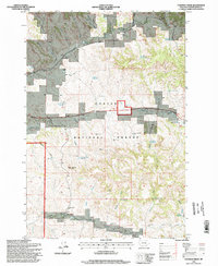
1995 Map of Coleman Draw
USGS Topo · Published 1998About this map
Custer National Forest defines the character of this Montana landscape, where the survival of ranching and industry depends entirely on scattered water sources. The map reveals a sophisticated network of groundwater management, featuring numerous named wells and reservoirs like Coal Mine Project Well, Gaskill Reservoir, and Detborn Reservoir that sustain activity in the high plains. Local life and labor are centered around landmarks like the Home Creek School and the Bryan Mine Spring, while the terrain is marked by prominent elevations such as Red Top Hill. The drainage patterns of West Fork Prairie Creek and Home Creek shape the distribution of these resources across the Powder River County rangeland. This survey, updated with 1990s data, provides a clear view of the intersections between natural springs like Stafford Spring and the man-made infrastructure necessary for life in the eastern Montana backcountry.
Find a feature on this map
31 named features on this map. Tap any name to fly to it.
Don’t see what you’re looking for? This feature index may not catch every label — zoom into the map to look around manually.
Map Details
Editions of this 1995 Coleman Draw Map
This is the sole edition of this map. No revisions or reprints were ever made.
Other maps of this area

1954 · Hardin
USGS Topo · 1:250,000

1954 · Ekalaka
USGS Topo · 1:250,000

1956 · Ekalaka
USGS Topo · 1:250,000

1957 · Hardin
USGS Topo · 1:250,000

1958 · Ekalaka
USGS Topo · 1:250,000

1958 · Hardin
USGS Topo · 1:250,000

1965 · Ekalaka
USGS Topo · 1:250,000

1966 · Coleman Draw
USGS Topo · 1:24,000

1966 · Stacey
USGS Topo · 1:24,000

1966 · Home Creek Butte
USGS Topo · 1:24,000