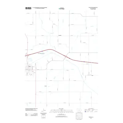
2013 Map of Colfax
USGS Topo · Published 2013About this map
The S Skunk River carves a path through this section of central Iowa, defining the local geography alongside several major tributaries. The city of Colfax anchors the western edge of the map, showing a dense street grid transitioning into the managed wetlands and recreational spaces of the Colfax Public Hunting Area. In this era, the surrounding landscape is a network of rural routes and small agricultural outposts such as Goddard, Severs, and Metz. The drainage pattern is complex, with Indian Creek, Prairie Cr, and Severs Cr feeding into the river system. These waterways historically influenced the placement of early settlements and roads, many of which follow the natural contours of the valley floor before climbing into the upland prairies of Jasper County.
Find a feature on this map
60 named features on this map. Tap any name to fly to it.
Don’t see what you’re looking for? This feature index may not catch every label — zoom into the map to look around manually.
Map Details
Editions of this 2013 Colfax Map
This is the sole edition of this map. No revisions or reprints were ever made.
Other maps of this area

1930 · Mitchellville
USGS Topo · 1:62,500

1954 · Des Moines
USGS Topo · 1:250,000

1956 · Des Moines
USGS Topo · 1:250,000

1957 · Des Moines
USGS Topo · 1:250,000

1965 · Prairie City
USGS Topo · 1:24,000

1965 · Newton
USGS Topo · 1:24,000

1965 · Monroe
USGS Topo · 1:24,000

1965 · Colfax
USGS Topo · 1:24,000

1969 · Des Moines
USGS Topo · 1:250,000
1972 · Runnells
USGS Topo · 1:24,000