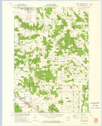
1972 Map of Colfax South
USGS Topo · Published 1975About this map
The Red Cedar River cuts through the northern landscape of this region, which was surveyed during the early 1970s. The village of Colfax sits at the top of the sheet, where the Soo Line railroad passes through town near Evergreen Cem. Further south, the terrain transitions into the town of Elk Mound, featuring the prominent Panther Hill and the community of Elk Mound itself.
Find a feature on this map
34 named features on this map. Tap any name to fly to it.
Don’t see what you’re looking for? This feature index may not catch every label — zoom into the map to look around manually.
Map Details
Editions of this 1972 Colfax South Map
This is the sole edition of this map. No revisions or reprints were ever made.
Other maps of this area

1934 · Elk Mound
USGS Topo · 1:62,500

1936 · Elk Mound
USGS Topo · 1:62,500

1940 · Menomonie
USGS Topo · 1:62,500

1942 · Menomonie
USGS Topo · 1:62,500

1949 · New Auburn
USGS Topo · 1:62,500

1949 · Ridgeland
USGS Topo · 1:62,500

1951 · Ridgeland
USGS Topo · 1:62,500

1951 · New Auburn
USGS Topo · 1:62,500

1953 · Eau Claire
USGS Topo · 1:250,000

1953 · Rice Lake
USGS Topo · 1:250,000