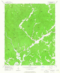
1956 Map of Collettsville
USGS Topo · Published 1965About this map
Collettsville serves as the central hub of this mid-century mountain landscape, situated at the confluence of the Johns River and Mulberry Creek. The 1956 survey reveals a network of rural communities and remote mountain peaks, including Joe White Mtn and High Knob, within the Pisgah National Forest. The topography is defined by sharp ridges like Baird Ridge and Sally Ridge that hem in the narrow river valleys where small settlements and country churches are found. Genealogists may find value in the distinct placement of local landmarks such as Conways Chapel, Green Valley Ch, and Fleming Chapel. The map also captures the path of the Johns River as it winds through the heart of the terrain, flanked by numerous small tributaries like Estes Mill Br and Lurkin Br, illustrating a settlement pattern deeply tied to the drainage systems of the Blue Ridge foothills.
Find a feature on this map
59 named features on this map. Tap any name to fly to it.
Don’t see what you’re looking for? This feature index may not catch every label — zoom into the map to look around manually.
Map Details
Editions of this 1956 Collettsville Map

Other maps of this area

1893 · Cranberry
USGS Topo · 1:125,000

1895 · Cranberry
USGS Topo · 1:125,000

1899 · Cranberry
USGS Topo · 1:125,000

1902 · Cranberry
USGS Topo · 1:125,000

1905 · Morganton
USGS Topo · 1:125,000

1936 · Blowing Rock
USGS Topo · 1:48,000

1942 · Blowing Rock
USGS Topo · 1:62,500

1944 · Linville
USGS Topo · 1:62,500

1953 · Charlotte
USGS Topo · 1:250,000

1953 · Winston-Salem
USGS Topo · 1:250,000