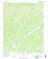
1956 Map of Collettsville
USGS Topo · Published 1965About this map
Pisgah National Forest encompasses the high, wooded ridges of this 1956 survey, where the Johns River and Mulberry Creek carve through the foothills of the Blue Ridge. The settlement at Collettsville serves as a central hub for the surrounding valleys, which are dotted with small community landmarks like Mulvale Ch and Green Valley Ch. The landscape is defined by its deep drainages and named summits, including Adams Mtn and Rocky Knob, illustrating a mid-century pattern of rural life where family and church names mark the geography. Along Wilson Creek, the presence of Brown Mtn Beach indicates the area's development as a site for outdoor recreation. Genealogists will find value in the numerous unnamed cemeteries (marked Cem) and smaller rural nodes like Rufus and Adako that characterize the Caldwell County backcountry.
Find a feature on this map
55 named features on this map. Tap any name to fly to it.
Don’t see what you’re looking for? This feature index may not catch every label — zoom into the map to look around manually.
Map Details
Editions of this 1956 Collettsville Map

Other maps of this area

1893 · Cranberry
USGS Topo · 1:125,000

1895 · Cranberry
USGS Topo · 1:125,000

1899 · Cranberry
USGS Topo · 1:125,000

1902 · Cranberry
USGS Topo · 1:125,000

1905 · Morganton
USGS Topo · 1:125,000

1936 · Blowing Rock
USGS Topo · 1:48,000

1942 · Blowing Rock
USGS Topo · 1:62,500

1944 · Linville
USGS Topo · 1:62,500

1953 · Charlotte
USGS Topo · 1:250,000

1953 · Winston-Salem
USGS Topo · 1:250,000