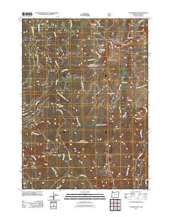
2011 Map of Collier Butte
USGS Topo · Published 2011About this map
The Pistol River and its numerous tributaries, including the East Fork Pistol River and Sunrise Creek, define this mountainous portion of Curry County. This 2011 survey documents a landscape dominated by timber management and remote outposts, where dozens of National Forest Development Roads provide access to high-elevation points like Collier Butte and Snow Camp Mountain. Named locations such as Stack Yards, Three Trees, and Hazel Camp suggest the area's legacy of logging or seasonal habitation. The topography is further marked by isolated water features such as Panther Lake and the Mineral Spring near Mineral Hill. In the northeast, Collier Creek flows through deep drainages toward the Chetco River, illustrating the complex watershed system of the Southern Oregon Coast Range during the early twenty-first century.
Find a feature on this map
40 named features on this map. Tap any name to fly to it.
Don’t see what you’re looking for? This feature index may not catch every label — zoom into the map to look around manually.
Map Details
Editions of this 2011 Collier Butte Map
This is the sole edition of this map. No revisions or reprints were ever made.
Other maps of this area

1954 · Coos Bay
USGS Topo · 1:250,000

1954 · Cape Ferrelo
USGS Topo · 1:62,500

1954 · Gold Beach
USGS Topo · 1:62,500

1954 · Collier Butte
USGS Topo · 1:62,500

1954 · Mt. Emily
USGS Topo · 1:62,500

1958 · Coos Bay
USGS Topo · 1:250,000

1962 · Coos Bay
USGS Topo · 1:250,000
1986 · Carpenterville
USGS Topo · 1:24,000
1986 · Sundown Mtn
USGS Topo · 1:24,000
1986 · Signal Buttes
USGS Topo · 1:24,000