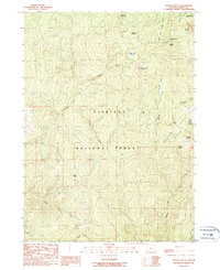
1989 Map of Collier Butte
USGS Topo · Published 1989About this map
Fairview Mountain and Collier Butte stand as prominent landmarks in this high-altitude reach of the Siskiyou National Forest during the late 1980s. The landscape is defined by the sharp drainage basins of the Pistol River and Chetco River, where remote outposts like Fairview Campground and Hazel Camp provided seasonal access for forestry and exploration. Land use patterns are evidenced by numerous prospects scattered near Snow Camp Mountain and Collier Butte, indicating a history of mineral exploration in the backcountry.
Find a feature on this map
55 named features on this map. Tap any name to fly to it.
Don’t see what you’re looking for? This feature index may not catch every label — zoom into the map to look around manually.
Map Details
Editions of this 1989 Collier Butte Map
This is the sole edition of this map. No revisions or reprints were ever made.
Other maps of this area

1954 · Coos Bay
USGS Topo · 1:250,000

1954 · Cape Ferrelo
USGS Topo · 1:62,500

1954 · Gold Beach
USGS Topo · 1:62,500

1954 · Collier Butte
USGS Topo · 1:62,500

1954 · Mt. Emily
USGS Topo · 1:62,500

1958 · Coos Bay
USGS Topo · 1:250,000

1962 · Coos Bay
USGS Topo · 1:250,000
1986 · Carpenterville
USGS Topo · 1:24,000
1986 · Sundown Mtn
USGS Topo · 1:24,000
1986 · Signal Buttes
USGS Topo · 1:24,000