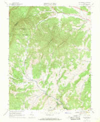
1967 Map of Collierstown
USGS Topo · Published 1969About this map
Collierstown serves as a central point of settlement in this Rockbridge County landscape, where the confluence of Colliers Creek and Hayslette Creek shapes the local valley. The terrain is dominated by the distinctive summits of Big House Mountain and Little House Mountain, which rise between the drainages of Whistle Creek and Sugar Creek. These peaks provide a natural barrier between the northern community of Denmark and the southern area of Effinger.
Find a feature on this map
29 named features on this map. Tap any name to fly to it.
Don’t see what you’re looking for? This feature index may not catch every label — zoom into the map to look around manually.
Map Details
Editions of this 1967 Collierstown Map
3 editions found
Other maps of this area

1894 · Natural Bridge
USGS Topo · 1:125,000

1894 · Lexington
USGS Topo · 1:125,000

1894 · Natural Bridge
USGS Topo · 1:62,500

1907 · Natural Bridge Special
USGS Topo · 1:62,500

1932 · Lexington
USGS Topo · 1:48,000

1935 · Buena Vista
USGS Topo · 1:48,000

1937 · Lexington
USGS Topo · 1:62,500

1939 · Buena Vista
USGS Topo · 1:62,500

1940 · Buena Vista
USGS Topo · 1:62,500

1946 · Millboro
USGS Topo · 1:62,500