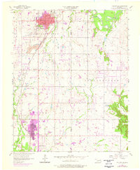
1956 Map of Collinsville
USGS Topo · Published 1976About this map
Collinsville and Owasso anchor this mid-century survey of the Tulsa Co Rogers Co border, a landscape shaped by coal extraction and early municipal growth. The Atchison Topeka and Santa Fe railroad runs diagonally through the territory, passing the massive Strip Mine operations that once dominated the western sections. In Collinsville, local life centers on City Hall, Central High Sch, and the nearby Ridgelawn Cem, while the northern reaches are defined by the winding course of the Caney River and the high ground of Sand Ridge. The southern portion of the sheet reveals the early development of Owasso, including Owasso Lake and several family-linked landmarks like Fairview Cem. Between these hubs, the terrain is marked by smaller waterways such as Blackjack Creek and Hobbs Creek, supporting a mix of agricultural land and industrial infrastructure including a Landing Field.
Find a feature on this map
26 named features on this map. Tap any name to fly to it.
Don’t see what you’re looking for? This feature index may not catch every label — zoom into the map to look around manually.
Map Details
Editions of this 1956 Collinsville Map
3 editions found
Other maps of this area

1901 · Claremore
USGS Topo · 1:125,000

1914 · Claremore
USGS Topo · 1:125,000

1916 · Claremore
USGS Topo · 1:125,000

1954 · Tulsa
USGS Topo · 1:250,000

1954 · Tulsa
USGS Topo · 1:24,000

1955 · Sperry
USGS Topo · 1:24,000

1955 · Mingo
USGS Topo · 1:24,000

1956 · Collinsville
USGS Topo · 1:24,000

1958 · Tulsa
USGS Topo · 1:250,000

1959 · Collinsville NE
USGS Topo · 1:24,000