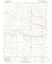
1969 Map of Colony Township NW
USGS Topo · Published 1993About this map
South Ladder Creek meanders through the high plains of the Colorado-Kansas border, carving a shallow valley across a landscape defined by township boundaries and sparse agricultural development. This late-1960s survey documents the intersection of Cheyenne County and Greeley County along the state line, where the arid terrain is marked primarily by scattered wells and a small Gravel Pit. The map captures the quiet transition between Weskan and Colony, illustrating a region where surveyor lines and natural watercourses dictate the human imprint on the land. The presence of these boundary markers and isolated industrial points provides a specific record of land use and resource extraction in a low-density rural corridor during the late twentieth century.
Find a feature on this map
9 named features on this map. Tap any name to fly to it.
Don’t see what you’re looking for? This feature index may not catch every label — zoom into the map to look around manually.
Map Details
Editions of this 1969 Colony Township NW Map
3 editions found
Other maps of this area

1892 · Cheyenne Wells
USGS Topo · 1:125,000

1894 · Cheyenne Wells
USGS Topo · 1:125,000

1954 · Lamar
USGS Topo · 1:250,000

1955 · Scott City
USGS Topo · 1:250,000

1958 · Lamar
USGS Topo · 1:250,000

1958 · Scott City
USGS Topo · 1:250,000

1959 · Weskan
USGS Topo · 1:62,500

1968 · Sharon Springs 3 NW
USGS Topo · 1:24,000

1969 · Arapahoe SE
USGS Topo · 1:24,000

1969 · Cheyenne Wells 4 NE
USGS Topo · 1:24,000