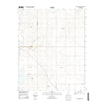
2013 Map of Colorado Canyon
USGS Topo · Published 2013About this map
Lake Sumner and the intricate draws of Colorado Canyon dominate this landscape in eastern New Mexico. The terrain is marked by the winding course of Alamogordo Cr as it feeds into the lake, creating a complex drainage system across the high plains. Ranching operations are the primary human footprint, with the McRee Ranch and Head Ranch serving as focal points for the surrounding grazing lands. A network of rural routes, including Alamo Rd, Ranger Rd, and Head Ranch Rd, connects these isolated homesteads across the county line between Guadalupe and De Baca counties. The placement of Us-84 cutting diagonally across the western sections highlights the critical transportation corridor through this arid region, providing a contrast to the secondary tracks like Roping Rd and Little Drum Rd that service the interior ranch land.
Find a feature on this map
18 named features on this map. Tap any name to fly to it.
Don’t see what you’re looking for? This feature index may not catch every label — zoom into the map to look around manually.
Map Details
Editions of this 2013 Colorado Canyon Map
This is the sole edition of this map. No revisions or reprints were ever made.
Other maps of this area

1954 · Fort Sumner
USGS Topo · 1:250,000

1958 · Fort Sumner
USGS Topo · 1:250,000

1964 · Canada Colorado
USGS Topo · 1:24,000

1964 · Fallon Ranch
USGS Topo · 1:24,000

1965 · Windmill Draw
USGS Topo · 1:24,000

1966 · Gibbons Ranch
USGS Topo · 1:24,000

1966 · Alamogordo Dam
USGS Topo · 1:24,000

1966 · Colorado Canyon
USGS Topo · 1:24,000

1968 · Twin Mesa NW
USGS Topo · 1:24,000

1968 · Twin Mesa
USGS Topo · 1:24,000