
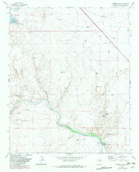
1965 Map of Windmill Draw
USGS Topo · Published 1969About this map
The Pecos River cuts through this high desert landscape, defining the hydrological and social character of the region in the mid-1960s. Water management is central to the area's layout, anchored by the Alamogordo Res in the northwest and the intricate engineering of the Fort Sumner Diversion Dam and Fort Sumner Main Canal in the south. These features supported a ranching economy visible through named homesteads like York Ranch, Walton Ranch, and Brassel Ranch. Numerous scattered windmills, including North Windmill and the Winter Horse Pasture Windmill, indicate the necessity of groundwater for livestock in this arid terrain. The map also records several unnamed Ruins along Windmill Draw and the riverbanks, suggesting earlier periods of habitation or seasonal use near landmarks like Pacheco Bluff.
Find a feature on this map
34 named features on this map. Tap any name to fly to it.
Don’t see what you’re looking for? This feature index may not catch every label — zoom into the map to look around manually.
Map Details
Editions of this 1965 Windmill Draw Map
2 editions found
Other maps of this area

1954 · Fort Sumner
USGS Topo · 1:250,000

1958 · Fort Sumner
USGS Topo · 1:250,000

1965 · Fort Sumner West
USGS Topo · 1:24,000

1966 · Gibbons Ranch
USGS Topo · 1:24,000

1966 · Ricardo
USGS Topo · 1:24,000

1966 · Alamogordo Dam
USGS Topo · 1:24,000

1966 · Colorado Canyon
USGS Topo · 1:24,000

1968 · Twin Mesa NW
USGS Topo · 1:24,000

1968 · Fort Sumner East
USGS Topo · 1:24,000

1968 · Twin Mesa
USGS Topo · 1:24,000