
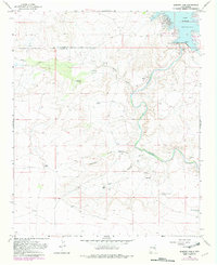
1966 Map of Alamogordo Dam
USGS Topo · Published 1969About this map
The Alamogordo Reservoir and the Alamogordo Dam anchor this mid-1960s survey of the high plains where the Pecos River carves through the landscape. Located along the boundary of Guadalupe and De Baca counties, the map documents a semi-arid ranching environment defined by water management and isolated settlements. Cattle ranching history is evident in named sites such as the Koontz Ranch and Trujillo Ranch, while scattered Ruins suggest older habitations near Salado Creek. A network of water infrastructure supports the local economy, from the Gaging Station below the dam to family-named wells like the Jose Maria Windmill and the West Sand Springs Windmill. Significant local heritage is also preserved at the Guadalupe Cem, located on a bluff overlooking the river valley.
Find a feature on this map
23 named features on this map. Tap any name to fly to it.
Don’t see what you’re looking for? This feature index may not catch every label — zoom into the map to look around manually.
Map Details
Editions of this 1966 Alamogordo Dam Map
2 editions found
Other maps of this area

1954 · Fort Sumner
USGS Topo · 1:250,000

1958 · Fort Sumner
USGS Topo · 1:250,000

1965 · Fort Sumner West
USGS Topo · 1:24,000

1965 · Windmill Draw
USGS Topo · 1:24,000

1966 · Gibbons Ranch
USGS Topo · 1:24,000

1966 · Ricardo
USGS Topo · 1:24,000

1966 · Ojo Negro Creek
USGS Topo · 1:24,000

1966 · Cooper Ranch
USGS Topo · 1:24,000

1966 · Colorado Canyon
USGS Topo · 1:24,000

1966 · Yeso
USGS Topo · 1:24,000