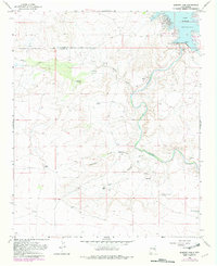
1966 Map of Sumner Dam
USGS Topo · Published 1982About this map
The Pecos River carves a deep, winding path through this portion of eastern New Mexico, where the massive Sumner Dam regulates flow and creates the expansive Lake Sumner. This 1966 survey, with 1982 edits, captures a semi-arid landscape defined by its critical water sources and livestock ranching infrastructure. Numerous Ruins dot the terrain near the Salado Creek drainage, suggesting a long history of habitation along these waterways.
Find a feature on this map
21 named features on this map. Tap any name to fly to it.
Don’t see what you’re looking for? This feature index may not catch every label — zoom into the map to look around manually.
Map Details
Editions of this 1966 Sumner Dam Map
2 editions found
Other maps of this area

1954 · Fort Sumner
USGS Topo · 1:250,000

1958 · Fort Sumner
USGS Topo · 1:250,000

1965 · Fort Sumner West
USGS Topo · 1:24,000

1965 · Windmill Draw
USGS Topo · 1:24,000

1966 · Gibbons Ranch
USGS Topo · 1:24,000

1966 · Ricardo
USGS Topo · 1:24,000

1966 · Ojo Negro Creek
USGS Topo · 1:24,000

1966 · Alamogordo Dam
USGS Topo · 1:24,000

1966 · Cooper Ranch
USGS Topo · 1:24,000

1966 · Colorado Canyon
USGS Topo · 1:24,000