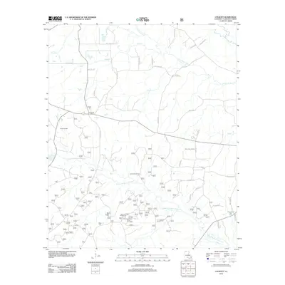
2012 Map of Colquitt
USGS Topo · Published 2012About this map
Colquitt serves as a central hub for the surrounding Claiborne Parish countryside, where the landscape is defined by the intersection of the petroleum industry and meandering waterways. Extensive energy operations are recorded throughout the area, including the Colquitt Oil Field, Summerfield Oil Field, and the Antioch Oil and Gas Field. These industrial sites are interspersed with family-named roads such as Ray Odom Rd and Jeff Bailey Rd, suggesting a landscape where local lineage and land ownership remain closely tied. The natural geography is dominated by the Middle Fork Bayou D'Arbonne and Little Cornie Bayou, which carve through the terrain alongside low-lying areas like Cypress Btm. For those researching local history or genealogy, the presence of Colquitt Cem and Monk Cem provide specific points of reference for the families who settled this region of northern Louisiana.
Find a feature on this map
54 named features on this map. Tap any name to fly to it.
Don’t see what you’re looking for? This feature index may not catch every label — zoom into the map to look around manually.
Map Details
Editions of this 2012 Colquitt Map
This is the sole edition of this map. No revisions or reprints were ever made.
Other maps of this area

1951 · Summerfield
USGS Topo · 1:62,500

1952 · Homer
USGS Topo · 1:62,500

1953 · El Dorado
USGS Topo · 1:250,000

1955 · Shreveport
USGS Topo · 1:250,000

1956 · Shreveport
USGS Topo · 1:250,000

1957 · El Dorado
USGS Topo · 1:250,000

1958 · El Dorado
USGS Topo · 1:250,000

1960 · El Dorado
USGS Topo · 1:250,000
1971 · Wesson
USGS Topo · 1:24,000
1971 · Emerson SE
USGS Topo · 1:24,000