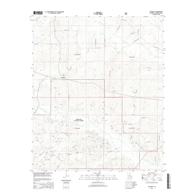
2015 Map of Colquitt
USGS Topo · Published 2015About this map
The settlement of Colquitt serves as the focal point for this survey of the Louisiana-Arkansas borderlands in Claiborne Parish. The landscape is defined by the headwaters and tributaries of the D'Arbonne and Corney systems, including Middle Fork Bayou D'Arbonne and Corney Bayou. Much of the southern and central terrain is situated within the Kisatchie National Forest, where a dense network of forest roads like Fo Rd 913 and Fire Dist Rd 910 crisscross the timberlands. Family history is etched into the road names and small burial sites throughout the quadrangle, with Colquitt Cem and Monk Cem providing primary genealogical anchors. Roads such as Ray Odom Rd, Mack Foster Rd, and Jeff Bailey RD suggest a long-standing pattern of family-held tracts and rural homesteads in this corner of northern Louisiana.
Find a feature on this map
46 named features on this map. Tap any name to fly to it.
Don’t see what you’re looking for? This feature index may not catch every label — zoom into the map to look around manually.
Map Details
Editions of this 2015 Colquitt Map
This is the sole edition of this map. No revisions or reprints were ever made.
Other maps of this area

1951 · Summerfield
USGS Topo · 1:62,500

1952 · Homer
USGS Topo · 1:62,500

1953 · El Dorado
USGS Topo · 1:250,000

1955 · Shreveport
USGS Topo · 1:250,000

1956 · Shreveport
USGS Topo · 1:250,000

1957 · El Dorado
USGS Topo · 1:250,000

1958 · El Dorado
USGS Topo · 1:250,000

1960 · El Dorado
USGS Topo · 1:250,000
1971 · Wesson
USGS Topo · 1:24,000
1971 · Emerson SE
USGS Topo · 1:24,000