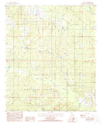
1986 Map of Colquitt
USGS Topo · Published 1986About this map
Colquitt serves as the primary settlement hub in this North Louisiana survey, situated at a crossroad where local timber and agricultural interests meet the northern reaches of the Kisatchie National Forest. The landscape is defined by an intricate network of waterways, most notably the winding Middle Fork Bayou D'Arbonne and the larger Corney Bayou to the north. These drainage systems, including Little Corney Bayou and Doe Branch, shaped the early settlement patterns and land use in Claiborne Parish. The map reveals the infrastructure of the mid-1980s, featuring a Pump Sta and several pipelines cutting through the wooded terrain, reflecting the region's energy and utility development. Genealogists may find interest in the marked Cem near the center of the township, while the detailed topography shows the numerous small drainages like Lick Creek and Steep Creek that partition the forest.
Find a feature on this map
12 named features on this map. Tap any name to fly to it.
Don’t see what you’re looking for? This feature index may not catch every label — zoom into the map to look around manually.
Map Details
Editions of this 1986 Colquitt Map
This is the sole edition of this map. No revisions or reprints were ever made.
Other maps of this area

1951 · Summerfield
USGS Topo · 1:62,500

1952 · Homer
USGS Topo · 1:62,500

1953 · El Dorado
USGS Topo · 1:250,000

1955 · Shreveport
USGS Topo · 1:250,000

1956 · Shreveport
USGS Topo · 1:250,000

1957 · El Dorado
USGS Topo · 1:250,000

1958 · El Dorado
USGS Topo · 1:250,000

1960 · El Dorado
USGS Topo · 1:250,000
1971 · Wesson
USGS Topo · 1:24,000
1971 · Emerson SE
USGS Topo · 1:24,000