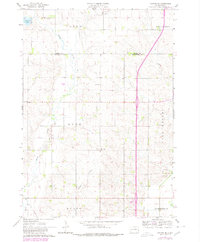
1962 Map of Colton SE
USGS Topo · Published 1980About this map
Skunk Creek winds through the agricultural townships of Burk and Lynn, anchoring a landscape shaped by rural industry and community life in eastern South Dakota. This mid-century survey, updated in the early 1980s, reveals a network of section-line roads connecting family-centered landmarks like the Burk Cem and Willow Creek Ch. The geography reflects the slow evolution of local transportation, from the presence of an Old Railroad Grade in the southwest corner to a small Landing Strip and modern highway developments. Along the eastern edge, the terrain transitions into the Dell Rapids and Sverdrup areas, where Gravel Pits indicate local resource extraction. Water features such as Anderson Slough and Willow Creek break up the cultivated fields, providing drainage and natural points of interest in this Minnehaha County region.
Find a feature on this map
16 named features on this map. Tap any name to fly to it.
Don’t see what you’re looking for? This feature index may not catch every label — zoom into the map to look around manually.
Map Details
Editions of this 1962 Colton SE Map
2 editions found
Other maps of this area

1955 · Sioux Falls
USGS Topo · 1:250,000

1958 · Sioux Falls
USGS Topo · 1:250,000

1962 · Colton SE
USGS Topo · 1:24,000

1962 · Dell Rapids
USGS Topo · 1:24,000

1962 · Renner
USGS Topo · 1:24,000

1962 · Hartford North
USGS Topo · 1:24,000

1962 · Crooks
USGS Topo · 1:24,000

1963 · Trent
USGS Topo · 1:24,000

1963 · Colman
USGS Topo · 1:24,000

1968 · Wentworth
USGS Topo · 1:24,000