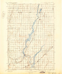
1896 Map of Columbia
USGS Topo · Published 1932About this map
The James River valley defines this late nineteenth-century landscape along the North Dakota South Dakota Boundary Line. A dense network of early rail lines, including the Chicago and Northwestern R. R. and the Chicago Milwaukee and St. Paul R. R., crisscrosses the prairie to connect emerging wheat-belt settlements. Significant hydrologic features like Sand Lake and Lake Columbia emphasize the importance of the river system for early regional development. The map reveals a highly structured township system with names like Liberty, Brainard, and Lansing etched into the surveyor's grid. These boundaries and the clustered settlements of Columbia, Hecla, and Claremont reflect the rapid agrarian expansion in Brown County before the turn of the century.
Find a feature on this map
47 named features on this map. Tap any name to fly to it.
Don’t see what you’re looking for? This feature index may not catch every label — zoom into the map to look around manually.
Map Details
Editions of this 1896 Columbia Map
3 editions found
Other maps of this area

1894 · Monango
USGS Topo · 1:62,500

1894 · Ellendale
USGS Topo · 1:62,500

1894 · Hecla
USGS Topo · 1:62,500

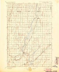
1894 · Columbia
USGS Topo · 1:62,500

1894 · Savo
USGS Topo · 1:62,500

1894 · Fullerton
USGS Topo · 1:62,500

1894 · Oakes
USGS Topo · 1:62,500

1895 · Lamoure
USGS Topo · 1:125,000

1895 · Aberdeen
USGS Topo · 1:125,000

1896 · Columbia
USGS Topo · 1:125,000