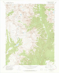
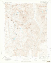
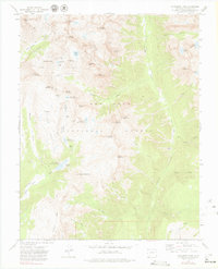
1973 Map of Columbine Pass
USGS Topo · Published 1975About this map
Needle Mountains peaks dominate this high-elevation corner of the San Juan National Forest, where the topography reflects a long history of alpine water management and mineral extraction. The map documents several critical reservoirs for the region, including City Reservoir (Durango Res No 1), Lake Marie (Durango Res No 2), and Lillie Lake (Durango Res No 3), all linked to the drainage of the Florida River.
Find a feature on this map
69 named features on this map. Tap any name to fly to it.
Don’t see what you’re looking for? This feature index may not catch every label — zoom into the map to look around manually.
Map Details
Editions of this 1973 Columbine Pass Map
4 editions found

Other maps of this area

1900 · Needle Mountains
USGS Topo · 1:62,500

1902 · Needle Mountains
USGS Topo · 1:62,500

1905 · San Cristobal
USGS Topo · 1:125,000

1907 · San Cristobal
USGS Topo · 1:125,000

1908 · Ignacio
USGS Topo · 1:125,000

1924 · Ignacio
USGS Topo · 1:125,000

1924 · Pagosa Springs
USGS Topo · 1:125,000

1927 · Pagosa Springs
USGS Topo · 1:125,000

1945 · Durango
USGS Topo · 1:250,000

1953 · Durango
USGS Topo · 1:250,000