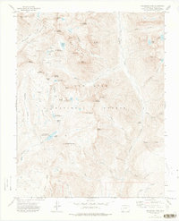
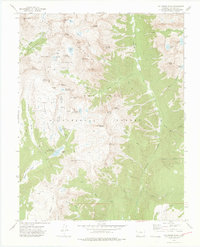
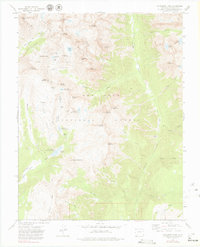
1973 Map of Columbine Pass
USGS Topo · Published 1975About this map
The high peaks of the San Juan Mountains dominate this mid-1970s survey, revealing a landscape defined by industrial water management and early mining efforts. Within the San Juan National Forest, the map identifies several numbered municipal reservoirs, including City Reservoir (Durango Res No 1), Lake Marie (Durango Res No 2), and Lillie Lake (Durango Res No 8), which provided essential water storage for the region. Historical activity is marked by the Logtown (Site) and the Pittsburg Mine located near Silver Mesa. Steep drainage basins like the Chicago Basin and Vallecito Basin are accessible only by specialized routes such as the Needle Creek Trail. This study serves as a record of the remote high-altitude terrain before modern infrastructure, where prominent summits like Mount Eolus and Windom Peak overlook the headwaters of the Florida River.
Find a feature on this map
61 named features on this map. Tap any name to fly to it.
Don’t see what you’re looking for? This feature index may not catch every label — zoom into the map to look around manually.
Map Details
Editions of this 1973 Columbine Pass Map
4 editions found

Other maps of this area

1900 · Needle Mountains
USGS Topo · 1:62,500

1902 · Needle Mountains
USGS Topo · 1:62,500

1905 · San Cristobal
USGS Topo · 1:125,000

1907 · San Cristobal
USGS Topo · 1:125,000

1908 · Ignacio
USGS Topo · 1:125,000

1924 · Ignacio
USGS Topo · 1:125,000

1924 · Pagosa Springs
USGS Topo · 1:125,000

1927 · Pagosa Springs
USGS Topo · 1:125,000

1945 · Durango
USGS Topo · 1:250,000

1953 · Durango
USGS Topo · 1:250,000