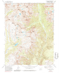
1973 Map of Columbine Pass
USGS Topo · Published 1987About this map
The Needle Mountains dominate this high-altitude landscape within the San Juan National Forest, where jagged peaks like Mount Eolus and Windom Peak rise above glaciated basins. The 1970s terrain reveals a legacy of water management and resource extraction, notably the City Reservoir (Durango Res No 1) and the Pittsburg Mine located along Missouri Gulch. The presence of the Logtown (Site) near Lake Marie points to a vanished era of mountain activity, likely associated with the timber or mining industries that once thrived in these elevations.
Find a feature on this map
62 named features on this map. Tap any name to fly to it.
Don’t see what you’re looking for? This feature index may not catch every label — zoom into the map to look around manually.
Map Details
Editions of this 1973 Columbine Pass Map
4 editions found
Other maps of this area

1900 · Needle Mountains
USGS Topo · 1:62,500

1902 · Needle Mountains
USGS Topo · 1:62,500

1905 · San Cristobal
USGS Topo · 1:125,000

1907 · San Cristobal
USGS Topo · 1:125,000

1908 · Ignacio
USGS Topo · 1:125,000

1924 · Ignacio
USGS Topo · 1:125,000

1924 · Pagosa Springs
USGS Topo · 1:125,000

1927 · Pagosa Springs
USGS Topo · 1:125,000

1945 · Durango
USGS Topo · 1:250,000

1953 · Durango
USGS Topo · 1:250,000