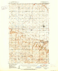
1950 Map of Columbus
USGS Topo · Published 1950About this map
The Canada United States international boundary defines the northern edge of this Burke County landscape, where the prairie was once busy with coal extraction and rail transport. A prominent Strip Mine and the Coalfield district underscore the region's industrial foundations during the late 1940s. The settlement of Columbus serves as a primary hub, supported by smaller locales like Larson and Kincaid. The transportation network is anchored by the Great Northern and the Minneapolis St Paul and Sault Ste Marie railroads, which facilitated the movement of resources through stops such as Strange Siding.
Find a feature on this map
39 named features on this map. Tap any name to fly to it.
Don’t see what you’re looking for? This feature index may not catch every label — zoom into the map to look around manually.
Map Details
Editions of this 1950 Columbus Map
2 editions found

Other maps of this area

1947 · Noonan
USGS Topo · 1:24,000

1947 · Columbus
USGS Topo · 1:24,000

1948 · Beaver Lake
USGS Topo · 1:24,000

1948 · Stampede
USGS Topo · 1:24,000

1949 · Columbus SW
USGS Topo · 1:24,000

1949 · Atcoal
USGS Topo · 1:24,000

1949 · Columbus
USGS Topo · 1:24,000

1949 · Noonan SE
USGS Topo · 1:24,000

1949 · Columbus SE
USGS Topo · 1:24,000

1949 · Noonan
USGS Topo · 1:24,000