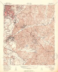
1947 Map of Columbus
USGS Topo · Published 1954About this map
Columbus serves as the urban anchor of this post-war landscape, situated along the Chattahoochee River as it forms the border between Georgia and Alabama. The city's growth is marked by residential developments like Baker Village and Benning Park Homes, while the extensive Fort Benning Military Reservation dominates the landscape to the south and east. This military presence is defined by a dense network of specialized areas including Lawson Field, Normandy Field, and numerous training grounds such as the Parachute Jump Towers and Cartouche Rifle Range.
Find a feature on this map
126 named features on this map. Tap any name to fly to it.
Don’t see what you’re looking for? This feature index may not catch every label — zoom into the map to look around manually.
Map Details
Editions of this 1947 Columbus Map
2 editions found
Other maps of this area

1907 · Talbotton
USGS Topo · 1:125,000

1907 · Opelika
USGS Topo · 1:125,000

1908 · Columbus
USGS Topo · 1:62,500

1909 · Opelika
USGS Topo · 1:125,000

1914 · Seale
USGS Topo · 1:62,500

1929 · Columbus
USGS Topo · 1:48,000

1947 · Columbus
USGS Topo · 1:62,500

1949 · Midland
USGS Topo · 1:24,000

1949 · Fort Mitchell
USGS Topo · 1:24,000

1949 · Glen Alta
USGS Topo · 1:24,000