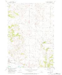
1956 Map of Columbus East
USGS Topo · Published 1973About this map
Columbus anchors the southwestern corner of this mid-century landscape, situated where the Yellowstone River and the Northern Pacific railroad corridor dictate the pace of local life and transport. The map reveals the critical infrastructure of the era, specifically the Columbus Water Association ditch, which marks the transition from the river valley to the dissected uplands. North of the settlement, the terrain is defined by a series of drainage systems including Keyser Creek, Wildcat Coulee, and Toms Creek, which carve into the ridges. These geographical features, including landmarks like Herder and Henry, illustrate the complex drainage patterns of Stillwater County before modern development significantly altered the rural Montana landscape.
Find a feature on this map
14 named features on this map. Tap any name to fly to it.
Don’t see what you’re looking for? This feature index may not catch every label — zoom into the map to look around manually.
Map Details
Editions of this 1956 Columbus East Map
2 editions found
Other maps of this area

1892 · Stillwater
USGS Topo · 1:125,000

1954 · Billings
USGS Topo · 1:250,000

1955 · Whitebird School
USGS Topo · 1:24,000

1956 · Columbus West
USGS Topo · 1:24,000

1956 · Hunter Lake
USGS Topo · 1:24,000

1956 · Shane Ridge
USGS Topo · 1:24,000

1956 · Horse Butte
USGS Topo · 1:24,000

1956 · Columbus East
USGS Topo · 1:24,000

1956 · Lindemulder Hill
USGS Topo · 1:24,000

1956 · Rapids
USGS Topo · 1:24,000