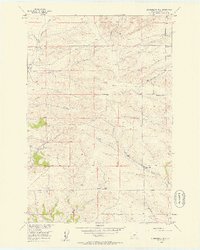
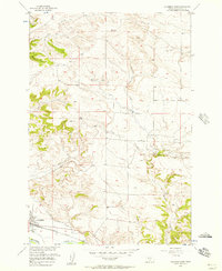
1956 Map of Lindemulder Hill
USGS Topo · Published 1958About this map
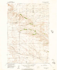
The Divide bisects this mid-century landscape in Stillwater County, separating the drainages that feed the region's complex creek network. This 1950s survey shows a rural environment defined by its natural topography and early infrastructure, including a prominent east-west pipeline and the local Mountain View Sch. The terrain is marked by significant elevations like Lindemulder Hill, Pershing Hill, and Lone Hill, which overlook the winding paths of East White Beaver Creek and Keyser Creek. These watercourses, along with Cottonwood Creek and Berry Creek, illustrate the drainage patterns essential to the ranching and agricultural operations of the era. The presence of the Base Line survey boundary and the VABM Beaver 4981 triangulation station highlights the meticulous mapping efforts conducted as part of the Missouri River Basin development program.
Find a feature on this map
15 named features on this map. Tap any name to fly to it.
Don’t see what you’re looking for? This feature index may not catch every label — zoom into the map to look around manually.
Map Details
Editions of this 1956 Lindemulder Hill Map
2 editions found
Other maps of this area

1892 · Stillwater
USGS Topo · 1:125,000

1954 · Billings
USGS Topo · 1:250,000
1955 · Antelope Point
USGS Topo · 1:24,000
1955 · Springtime
USGS Topo · 1:24,000
1955 · Russell Gulch
USGS Topo · 1:24,000
1956 · Columbus West
USGS Topo · 1:24,000
1956 · Rapelje
USGS Topo · 1:24,000
1956 · Battle Butte
USGS Topo · 1:24,000
1956 · Columbus East
USGS Topo · 1:24,000
1956 · Wheat Basin SW
USGS Topo · 1:24,000