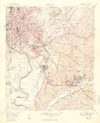
1949 Map of Columbus
USGS Topo · Published 1949About this map
Columbus and Phenix City face one another across the Chattahoochee River, serving as a vital industrial and military hub just after the war. The landscape is defined by the massive footprint of the Fort Benning Military Reservation, which occupies much of the southern and eastern territory, including settlements like Baker Village and Benning Hills. Industrial and transport networks are dense, with the Central of Georgia RR and Seaboard Air Line RR cutting through the urban core toward the R R Station.
Find a feature on this map
54 named features on this map. Tap any name to fly to it.
Don’t see what you’re looking for? This feature index may not catch every label — zoom into the map to look around manually.
Map Details
Editions of this 1949 Columbus Map
2 editions found

Other maps of this area

1907 · Talbotton
USGS Topo · 1:125,000

1907 · Opelika
USGS Topo · 1:125,000

1908 · Columbus
USGS Topo · 1:62,500

1909 · Opelika
USGS Topo · 1:125,000

1914 · Seale
USGS Topo · 1:62,500

1929 · Columbus
USGS Topo · 1:48,000

1947 · Columbus
USGS Topo · 1:62,500

1949 · Midland
USGS Topo · 1:24,000

1949 · Fort Mitchell
USGS Topo · 1:24,000

1949 · Ochillee
USGS Topo · 1:24,000