
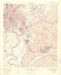
1949 Map of Columbus
USGS Topo · Published 1949About this map
Columbus and Phenix City stand as twin urban hubs divided by the Chattahoochee River in this post-war landscape. The map captures a moment of significant mid-century expansion, particularly to the south and east where military infrastructure dominates the landscape. The northern portion of the Fort Benning Military Reservation shapes the geography of Muscogee County, with specialized residential developments like Baker Village, Benning Park, and Benning Hills designed to support the growing garrison.
Find a feature on this map
56 named features on this map. Tap any name to fly to it.
Don’t see what you’re looking for? This feature index may not catch every label — zoom into the map to look around manually.
Map Details
Editions of this 1949 Columbus Map
2 editions found
Other maps of this area

1907 · Talbotton
USGS Topo · 1:125,000

1907 · Opelika
USGS Topo · 1:125,000

1908 · Columbus
USGS Topo · 1:62,500

1909 · Opelika
USGS Topo · 1:125,000

1914 · Seale
USGS Topo · 1:62,500

1929 · Columbus
USGS Topo · 1:48,000

1947 · Columbus
USGS Topo · 1:62,500

1949 · Midland
USGS Topo · 1:24,000

1949 · Fort Mitchell
USGS Topo · 1:24,000

1949 · Ochillee
USGS Topo · 1:24,000