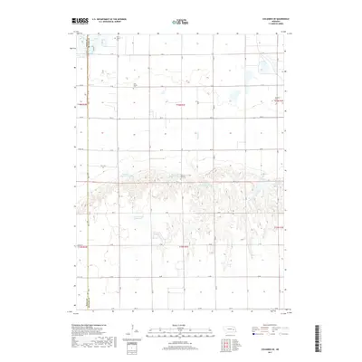
2017 Map of Columbus SE
USGS Topo · Published 2017About this map
Saint Joseph Cem sits near the northern boundary of this agricultural landscape in Butler County, marking a site of local heritage within the grid of rural roads. The terrain is defined by a transition from the level bottomlands near Clear Creek and Clear Lake in the northwest to more dissected drainage patterns further south. This area is characterized by an extensive water management system, including the Gruenewald Reservoir and a series of numbered basins such as Bellwood Reservoir 3-A and Bellwood Reservoir 3-C. These features suggest a highly engineered approach to irrigation and conservation common in this part of the Platte River valley region. Family history researchers will find significance in the distributed burial sites, including Pleasant View Cem and Bellwood Cem, which anchor the various townships shown across the survey.
Find a feature on this map
34 named features on this map. Tap any name to fly to it.
Don’t see what you’re looking for? This feature index may not catch every label — zoom into the map to look around manually.
Map Details
Editions of this 2017 Columbus SE Map
This is the sole edition of this map. No revisions or reprints were ever made.
Other maps of this area

1899 · David City
USGS Topo · 1:125,000

1955 · Fremont
USGS Topo · 1:250,000

1957 · Fremont
USGS Topo · 1:250,000

1958 · Fremont
USGS Topo · 1:250,000

1958 · Duncan
USGS Topo · 1:24,000

1958 · Columbus SW
USGS Topo · 1:24,000

1958 · Columbus SE
USGS Topo · 1:24,000

1958 · Columbus
USGS Topo · 1:24,000
1965 · Shelby
USGS Topo · 1:24,000
1965 · Garrison
USGS Topo · 1:24,000