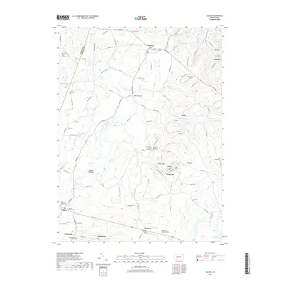
2019 Map of Colver
USGS Topo · Published 2019About this map
The northern reaches of the W Br Susquehanna River and the headwaters of North Branch Blacklick Creek define this landscape along the border of Indiana and Cambria counties. The settlement of Colver occupies a central position, characterized by a distinct residential grid including Nine Row and Twenty Row. This area is a significant site for genealogical research, containing numerous religious and family burial grounds such as Saint Nicholas Cem, Holy Ascension of Christ Orthodox Cem, and the Thomas Styles Cem. The region's infrastructure is marked by the presence of Krumenacker Airport and the Pindleton Lookout Tower near Pindleton. Water management and recreation are evident through the Colver Reservoir, Spangler Reservoir, and Duman Lake, illustrating how the local geography has been utilized for both industry and community use.
Find a feature on this map
125 named features on this map. Tap any name to fly to it.
Don’t see what you’re looking for? This feature index may not catch every label — zoom into the map to look around manually.
Map Details
Editions of this 2019 Colver Map
This is the sole edition of this map. No revisions or reprints were ever made.
Other maps of this area

1902 · Ebensburg
USGS Topo · 1:62,500

1902 · Patton
USGS Topo · 1:62,500

1902 · Barnesboro
USGS Topo · 1:62,500

1904 · Barnesboro
USGS Topo · 1:62,500

1904 · Patton
USGS Topo · 1:62,500

1904 · Ebensburg
USGS Topo · 1:62,500

1904 · Johnstown
USGS Topo · 1:62,500

1907 · Johnstown
USGS Topo · 1:62,500

1943 · Punxsutawney
USGS Topo · 1:125,000

1953 · Pittsburgh
USGS Topo · 1:250,000
Featured Places
- Bakersville, Cambria Township
- Pine Township, PA
- Twenty Row, Cambria Township
- Nine Row, Cambria Township
- Nicktown, Barr Township