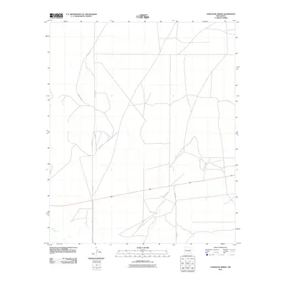
2010 Map of Comanche Spring
USGS Topo · Published 2010About this map
The high plains of eastern New Mexico are defined by a sparse but essential network of ranching roads in this 2010 survey by the U.S. Geological Survey. The landscape is primarily traversed by local thoroughfares such as Alamo Rd and Hachita Rd, which reflect the functional grid of Chaves County. This territory, largely characterized by open range and seasonal drainage patterns, relies on named connectors like Harral Rd to link remote tracts of land. The map illustrates a contemporary moment in the region's land use, where long-established county routes, including County Rd-61 and County Rd-63, provide the primary infrastructure for the ranching industry that continues to shape the New Mexico interior.
Find a feature on this map
6 named features on this map. Tap any name to fly to it.
Don’t see what you’re looking for? This feature index may not catch every label — zoom into the map to look around manually.
Map Details
Editions of this 2010 Comanche Spring Map
This is the sole edition of this map. No revisions or reprints were ever made.
Other maps of this area

1949 · Wade Ranch
USGS Topo · 1:24,000

1949 · L-E Ranch
USGS Topo · 1:24,000

1950 · Comanche Spring
USGS Topo · 1:24,000

1950 · Bottomless Lakes
USGS Topo · 1:24,000

1950 · South Spring
USGS Topo · 1:24,000

1950 · Bitter Lake
USGS Topo · 1:24,000

1955 · Roswell
USGS Topo · 1:250,000

1958 · Roswell
USGS Topo · 1:250,000

1962 · Roswell
USGS Topo · 1:250,000
1962 · South Spring
USGS Topo · 1:24,000