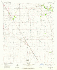
1962 Map of South Spring
USGS Topo · Published 1964About this map
The South Spring River and Rio Hondo converge toward the Pecos River in this 1962 topographical survey of Chaves County. This agricultural and military landscape is defined by the extensive Hagerman Canal system and the presence of Walker Air Force Base along the western edge. Small residential clusters and agricultural outposts like South Spring Acres, East Grand Plains, and Orchard Park are connected by the Atchison Topeka and Santa Fe railroad, which runs northwest to southeast through the quadrangle.
Find a feature on this map
28 named features on this map. Tap any name to fly to it.
Don’t see what you’re looking for? This feature index may not catch every label — zoom into the map to look around manually.
Map Details
Editions of this 1962 South Spring Map
2 editions found
Other maps of this area

1949 · Peters Lake
USGS Topo · 1:24,000

1949 · Roswell North
USGS Topo · 1:24,000

1949 · Roswell South
USGS Topo · 1:24,000

1950 · Dexter West
USGS Topo · 1:24,000

1950 · Comanche Spring
USGS Topo · 1:24,000

1950 · Bottomless Lakes
USGS Topo · 1:24,000

1950 · South Spring
USGS Topo · 1:24,000

1950 · Bitter Lake
USGS Topo · 1:24,000

1950 · Dexter East
USGS Topo · 1:24,000

1955 · Roswell
USGS Topo · 1:250,000