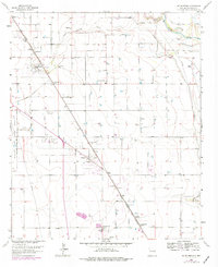
1962 Map of South Spring
USGS Topo · Published 1977About this map
The South Spring River and the Pecos River define the eastern edge of this Chaves County landscape, where agriculture and early aviation meet. The presence of Walker Air Force Base on the western boundary signals the Cold War-era military significance of the region, while the Hagerman Canal and various Gravel Pits illustrate the local reliance on irrigation and mineral extraction. Small residential clusters and agricultural centers like Fairbanks, East Grand Plains, and Midway are linked by the Atchison Topeka and Santa Fe railroad, which cuts diagonally across the terrain. Researchers will find distinct cultural markers of the mid-20th century, from the Drive-in Theater near Shady Grove to the industrial presence of Radio Towers and a Substation. Named holdings such as South Spring Ranch and Oasis Ranch provide evidence of established ranching operations during this period of development.
Find a feature on this map
31 named features on this map. Tap any name to fly to it.
Don’t see what you’re looking for? This feature index may not catch every label — zoom into the map to look around manually.
Map Details
Editions of this 1962 South Spring Map
2 editions found
Other maps of this area

1949 · Peters Lake
USGS Topo · 1:24,000

1949 · Roswell North
USGS Topo · 1:24,000

1949 · Roswell South
USGS Topo · 1:24,000

1950 · Dexter West
USGS Topo · 1:24,000

1950 · Comanche Spring
USGS Topo · 1:24,000

1950 · Bottomless Lakes
USGS Topo · 1:24,000

1950 · South Spring
USGS Topo · 1:24,000

1950 · Bitter Lake
USGS Topo · 1:24,000

1950 · Dexter East
USGS Topo · 1:24,000

1955 · Roswell
USGS Topo · 1:250,000