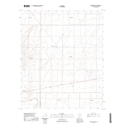
2020 Map of Comanche Spring
USGS Topo · Published 2020About this map
Comanche Spring serves as a critical water point in this arid stretch of Chaves County, centered in a landscape of high-desert draws and livestock ranges. The terrain is defined by the winding course of Comanche Draw, which cuts through the township sections toward the southeast. Surveyed in the early 21st century, the map reveals a network of rural roads that facilitate ranching and regional travel, including Alamo Rd, Hachita Rd, and Dulce Rd. The southern portion of the quadrangle shows the approach to notable geological features via Bottomless Lakes Rd, while Comanche Hill provides a distinct topographic landmark amidst the surrounding basin. This topographic study documents the persistent importance of named water sources and managed range lines in the modern New Mexico ranching economy.
Find a feature on this map
18 named features on this map. Tap any name to fly to it.
Don’t see what you’re looking for? This feature index may not catch every label — zoom into the map to look around manually.
Map Details
Editions of this 2020 Comanche Spring Map
This is the sole edition of this map. No revisions or reprints were ever made.
Other maps of this area

1949 · Wade Ranch
USGS Topo · 1:24,000

1949 · L-E Ranch
USGS Topo · 1:24,000

1950 · Comanche Spring
USGS Topo · 1:24,000

1950 · Bottomless Lakes
USGS Topo · 1:24,000

1950 · South Spring
USGS Topo · 1:24,000

1950 · Bitter Lake
USGS Topo · 1:24,000

1955 · Roswell
USGS Topo · 1:250,000

1958 · Roswell
USGS Topo · 1:250,000

1962 · Roswell
USGS Topo · 1:250,000
1962 · South Spring
USGS Topo · 1:24,000